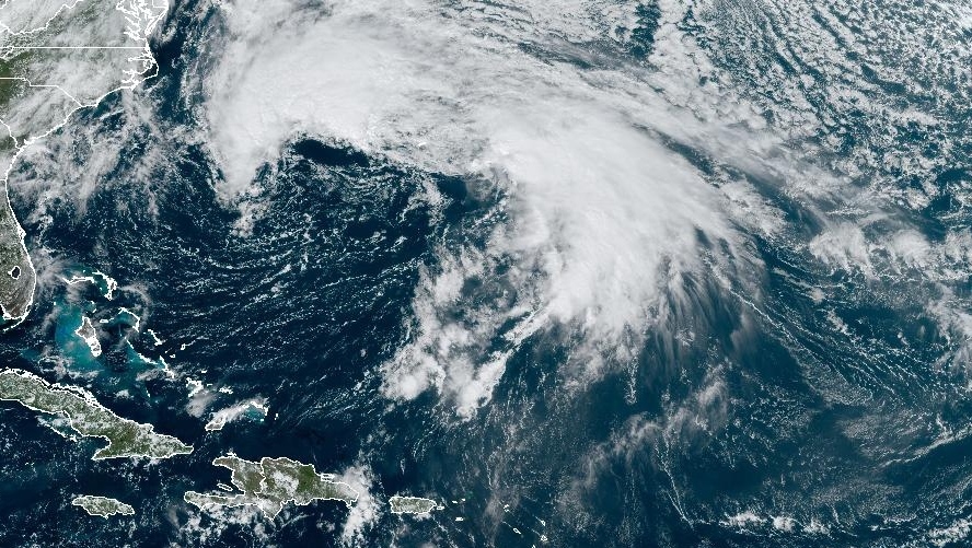
In the Friday noon update from the National Hurricane Center, Philippe was declared a post-tropical storm.
That does not mean a weakening of the storm. It does mean the structure of the storm has changed. It now has non-tropical characteristics, such as developing weather fronts and an asymmetrical appearance. The transition to post-tropical was forecasted and expected.
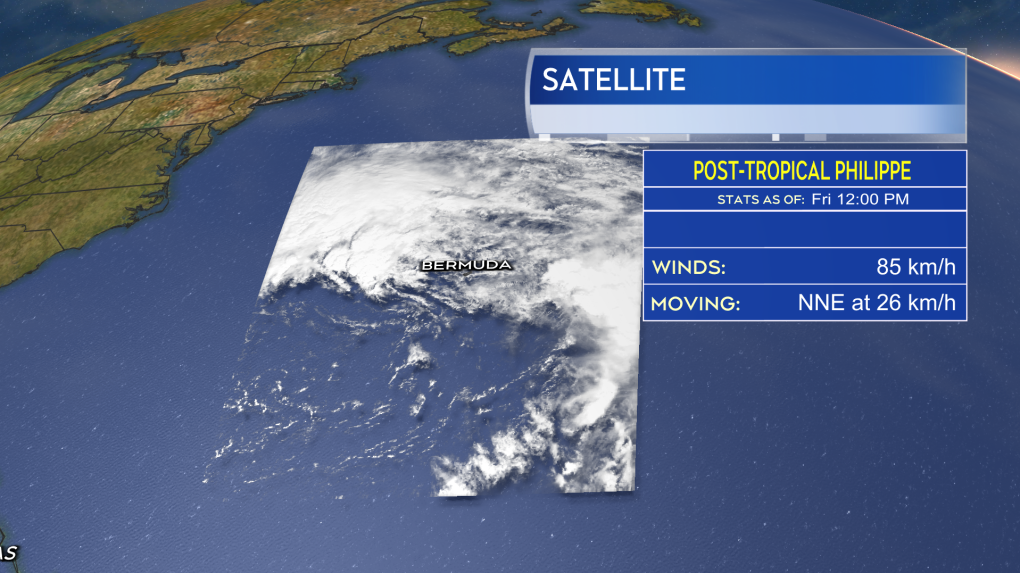 Now with non-tropical characteristics, including developing weather fronts, Philippe has been declared post-tropical.
Post-tropical storm Philippe will still continue north with the centre expected to pass just to the south of southwestern Nova Scotia before moving through Maine and into the St. Lawrence River Valley on Sunday.
As Philippe moves along that path, it will combine with a separate weather front to create a large area of low pressure — the fall storm we are expecting.
Due to it now being post-tropical, the Canadian Hurricane Centre has decided against issuing tropical storm watches and tropical storm warnings. Instead, they are advising to monitor for separate alerts, such as rain or wind warnings from the regional weather office.
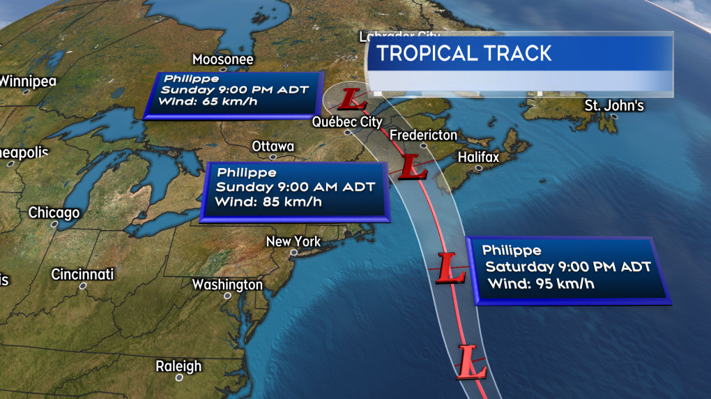 The track of post-tropical storm Philippe still takes it into the vicinity of the Maritimes where it combines with a weather front to produce a large fall storm.
NEW BRUNSWICK
It still looks like New Brunswick will contend with the rainiest and windiest conditions Saturday night through Sunday morning. The highest wind will be out of the east and southeast, with most gusts peaking between 40 and 80 km/h. I’d still rate a risk of stronger gusts of 80 to 90 km/h on and near the Bay of Fundy coastline as well as coastal areas of the Acadian Peninsula. Wind is still expected to turn southerly and diminish Sunday afternoon.
Rain will develop southwest to northeast across the province Saturday evening and night. The rain will persist into Sunday morning, but is expected to ease to a chance of showers for Sunday afternoon and evening. The highest risk of rain totals reaching 50 to 75 mm is along the border of New Brunswick and Maine. A lower risk of those higher rain amounts extends as far to the east as about the Fredericton area. Much of the rest of New Brunswick is likely to see totals ranging from 10 to 40 mm.
While wave action will increase in the Bay of Fundy Saturday night into Sunday, they are not expected to have much coastal impact.
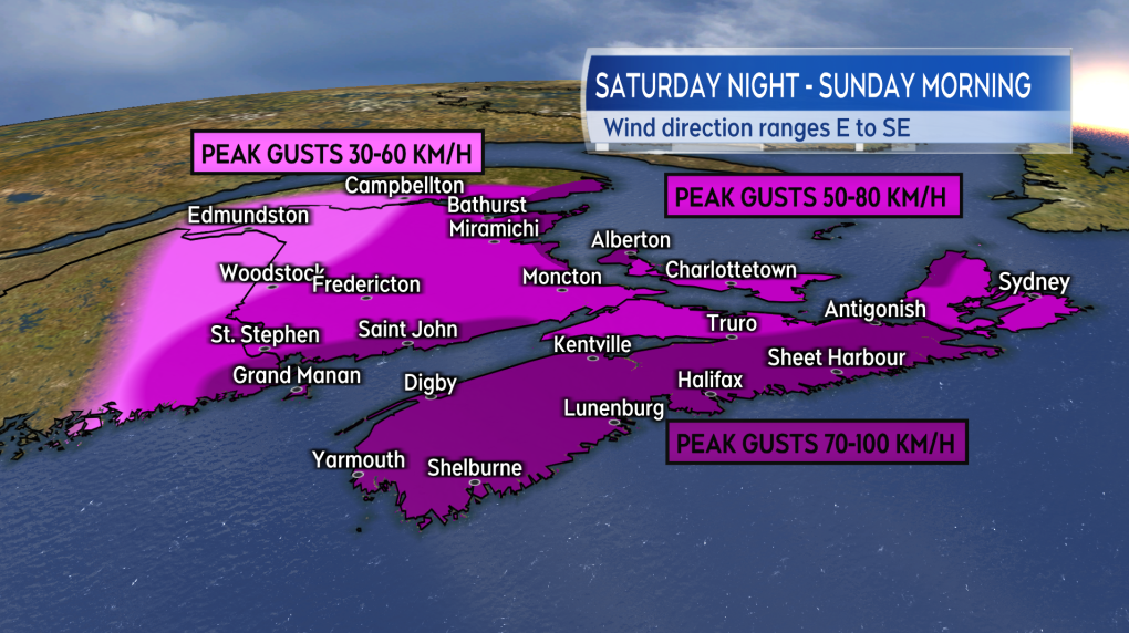 An outlook into peak wind gusts expected in the Maritime region with Philippe, with most of those occurring Saturday night and Sunday morning.
NOVA SCOTIA
Nova Scotia will see if most impact from post-tropical storm Philippe Saturday night through Sunday morning. Windy conditions could linger later into Sunday afternoon for eastern parts of the mainland and Cape Breton. The highest, gusty winds will be out of the east and southeast. For most of the province those winds will peak between 60 and 90 km/h. Exposed areas of the Atlantic coastline, particularly coastal areas of Yarmouth, Shelburne, Queens, and Lunenburg Counties, could see gusts as high as near 100 km/h. Northern Inverness County in Cape Breton could also hit some gusts of 100 km/h or higher on Sunday due to the topography of the Highlands.
Wind is expected to turn southwest and diminish by near noon Sunday for western Nova Scotia. For eastern parts of the province, the wind will turn southwest and diminish by the evening.
The rain may reach southwestern Nova Scotia late Saturday afternoon and develop across the province west-to-east Saturday night through Sunday morning. While not on the traditionally “rainy western side” of the storm, there is a risk of downpours within the rain. The greatest risk of rain pockets with totals of 50 to 75 mm is for counties that border the Atlantic coastline of the province. Widespread rain totals of 20 to 40 mm are expected provincewide. The rain is expected to clear western areas of Nova Scotia by noon on Sunday before clearing eastern areas, including Cape Breton, through Sunday afternoon.
While not matching Lee, large waves from Philippe are forecast for the South Shore and Halifax County Saturday night and Sunday morning. The greatest risk of elevated coastal water levels during high tide will occur between 4 a.m. and 5 a.m. for that area on Sunday. The Canadian Hurricane Centre notes some wave overwash and minor/moderate coastal flooding is a risk during those very early morning hours of Sunday.
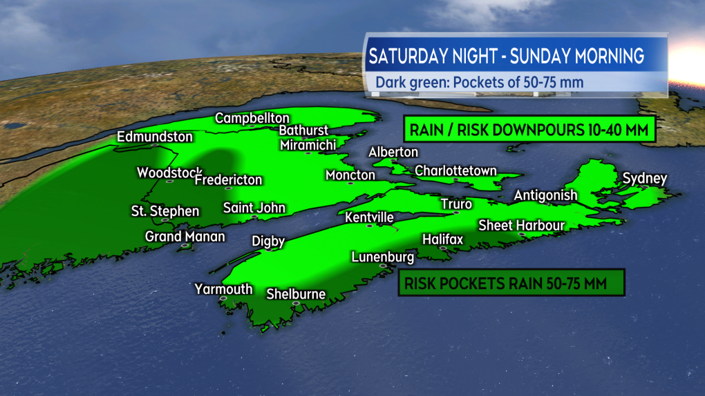 While rain totals for most of the region are not overly high, there is still a risk that it could come in the form of downpours at times.
PRINCE EDWARD ISLAND & MAGDALEN ISLANDS
Prince Edward Island and the Magdalen Islands will get into the rainy and windy weather in earnest early Sunday morning. The highest winds will be out of the east and southeast, with gusts mostly expected to peak 60 to 80 km/h. Areas of the coast more exposed to the east could reach gusts closer to 90 km/h. Windy conditions will persist through Sunday morning then gradually diminish in the afternoon into the evening.
Rain accompanying the wind will be in the range of 15 to 30 mm — that shouldn’t cause much issue. Like the wind, the rain will ease and clear through Sunday afternoon.
Some increased wave action is expected in the Gulf of St. Lawrence and Northumberland Strait on Sunday. The risk of coastal flooding remains low.
IN SUMMARY
Despite having a component that was originally tropical in nature, Philippe has all the marking of a strong, fall storm for the region. In general, the impacts are expected to be less than those with post-tropical storm Lee. While there is still a risk of power outages with the high and gusty winds, they are likely to be more scattered or isolated in occurrence.
While the risk of heavier rain is highest for a few particular areas, it would be a good idea to check drainage on properties. Make sure spouts and drains are free and clear of any early fall debris so the rain can flow away as unobstructed as possible.
I’ll have additional updates and coverage on the weather this weekend. That can all be found here at ctvnewsatlantic.ca.
